The Cohesive Strength Meter (CSM)
The importance of sediment dynamics
The erosion and transport of sediments is fundamental to the ecology and dynamics of many aquatic systems. Streams, rivers, lakes and the oceans all act as transport pathways for suspended sediments and where these sediment particles settle they often form important habitats that are exploited by a wide range of organisms. Perhaps the most familiar of these depositional habitats occur along the coastline. Mud flats, sandy beaches, saltmarshes and sand dunes all rely on a supply of sediment for their continued existence. Knowledge of the sediment transport pathways improves our ability to control and manage these systems. In addition, pollutants and nutrients are often carried with the sediment particles providing another reason to understand sediment dynamics. Finally, the ecology of depositional habitats is important, often providing direct or indirect services (ecosystem services) to the local community. Therefore understanding the stability of sediment and the forces that would be required to erode them from their surroundings is a valuable scientific objective.
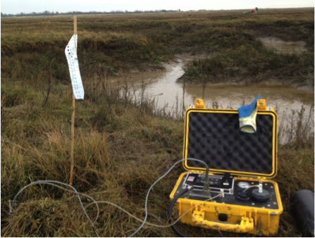 Figure 1 The CSM system in use
How can we measure sediment stability?
Broadly speaking sediment stability describes how resistant sediment is to erosion. The traditional method of determining the erosive behaviour of sediment under flow conditions is the use of a flow channel or “flume”. Flumes are frequently found in engineering and physics laboratories but are less well known in biology or ecology laboratories. This is changing as the importance of flow on the ecology of ecosystems is recognised. However, flumes are often large, can be well over 10 meters in length and are complex to use so cannot provide data from natural environments. Portable flumes that can be deployed in the field have been constructed but they are generally hard to deploy and slow to use. The CSM system is an alternative device which is small, easy to use and relatively inexpensive (Figure 1). It consists of a small water filled chamber which is inserted into the sediment. A downward nozzle directs a vertical jet pulse of water onto the sediment surface. The pressure of the water jet systematically increases and the transmission of infrared light across the test chamber is recorded. When sediment is eroded from the surface there is a reduction of transmission in the test chamber. A drop in transmission of 10% is usually taken as an indication that the bed has been eroded. This corresponds to erosion of approximately 0.01 kg sediment m-2 (Tolhurst et al. 2000). The pressure step when this drop occurs is taken as the critical eroding pressure (kPa) which can be converted to an equivalent erosion shear stress (N.m2) by the equations given in Tolhurst et al. (1999). The larger the critical eroding pressure the more difficult the sediment is to erode. The CSM can be deployed rapidly and provide significant spatial coverage (Figure 2).
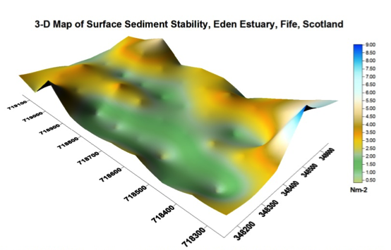 Figure 2 Surface map of sediment stability determined by the CSM system for The Eden estuary, Scotland